Here is an overview of some of the new features in Photo GPS Extract 7:
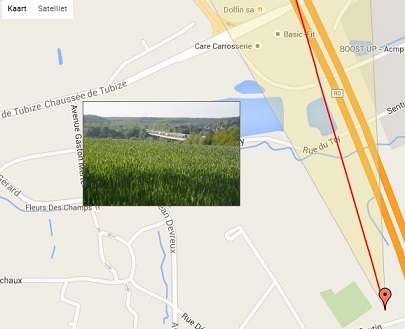
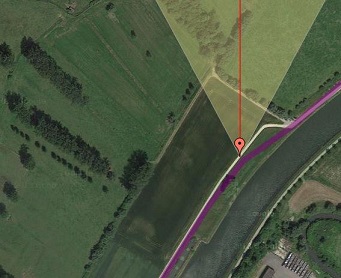
PGE 7 will be able to visualize the horizontal field of view, the triangular area that your camera sees. The angle depends on the focal length of your lens. A smaller focal length means a wider field of view.
If your photo contains some orientation information (bearing, 0...360 degrees), the displayed FOV will use the same orientation. So what you see on the photo should correspond with what you see on the map.
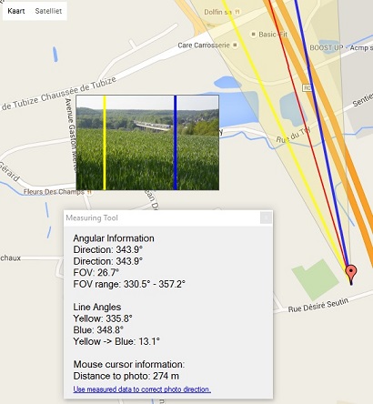
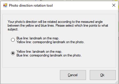
Of course I am well aware that most cameras do not record the bearing, as this requires an integrated compass. I found a workaround for this, and added some features to set the photo direction yourself. You can either guess the direction (set it manually), or you can use the new 'Angular Measuring Tool'.
The angular measuring tool allows you to measure angles between two custom lines. You can set these lines yourself by clicking the desired position within the displayed FOV.
One extremely useful and cool feature is that the displayed lines will also be shown on the 'preview image'. It helps you to locate visual elements from the photo on the map, and vice versa. This feature also allows you set the correct bearing for a photo. All you need is a fixed landmark on the photo, which is also visible on the map. Photo GPS Extract will be able to calculate the difference between them, and calculate the required offset to correct the bearing of the photo.
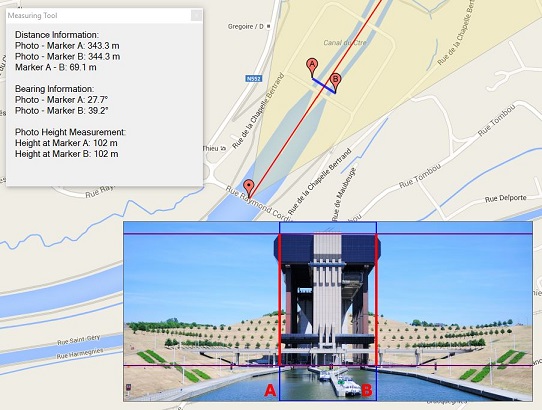
The distance measuring tool is very similar to the angular measuring tool, but it is used to measure distances between two points. You can set these points yourself. The corresponding positions will also be displayed on the preview image.
Since I found the angular measuring tool is quite accurate, I came up with the idea to build a tool to measure the HEIGHT of objects on pictures. You can set two horizontal lines on the preview image. The program will then calculate the vertical distance between both lines. It can be used to measure the height of trees or buildings. I didn't expect much of it, but it turned out the results are quite accurate. I have tested the tools on objects with known heights (like towers), the results were surprisingly good.
The quality of the height measuring tool will depend heavily on the correctness of your GPS location. The tool will have some limitations, but I will write a detailed article on how to properly use this tool.
Btw: the official height of the boat lift in Strepy is 103 meters!
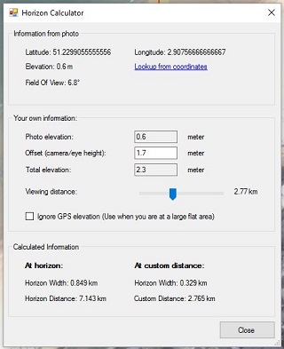
This feature allows you to calculate the distance to the horizon. This distance depends on your altitude: the higher you are, the further you can see. This tool will read the altitude from your photo, and then calculate the distance to the horizon. Of course, this tool assumes excellent weather conditions.
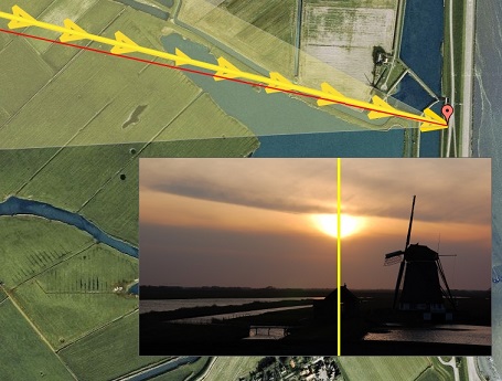
One cool new addition is the ability to visualize the position (azimuth) of the sun. This might give you a better idea on how a photo was taken: camera towards the sun or not, ... The calculation is based on the GPS coordinates from your photo, combined with the recorded EXIF-time.
Below you can find an example photo where I first corrected the direction using my 'Angular Measuring Tool'. I then enabled the sun on the map. As you can see in the preview image, the actual location of the sun corresponds with the calculated positon (yellow line).
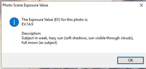
This is just a small gadget: the program can calculate the EV-value of a certain scene, together with an interpreted description. It tells you more about the lightning conditions of a scene.
The new Photo GPS Extract is capable to visualize a GPX tracklog on the map. It will automatically determine the tracklog that belongs to the current photo.
Ok, this is a feature I made just for myself: most of my GPS tracks, recorded by Garmin GPS devices, contain temperature data for each trackpoint. I added a feature that searches the GPX track, and displays the current temperature at the time the photo was taken.

Photo GPS Extract could already generate google Earth .KML files. But now, it will also have the possibility to show photos as rotated arrows. This will indicate the direction/bearing of each individual picture.
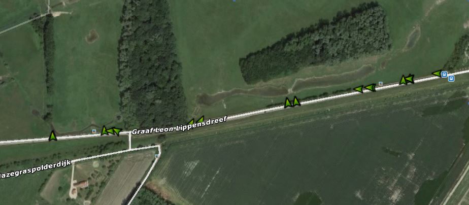
Photo GPS Extract will also be able to change the Exif information in some photos. You will be able to change the GPS-values: latitude, longitude, elevation and direction.
I didn't implement this feature before, because I didn't want to risk losing pictures because of bugs in my program (Exif can be tricky). But the new features, like the ability to change the photo direction, won't be very useful if the new information can't be updated in the photo.
Photo GPS Extract won't directly modify your pictures. Instead, it will use the well-known software 'ExifTool'. The author of this program has over 13 years of experience with Exif-manipulations. So, the software is very reliable.
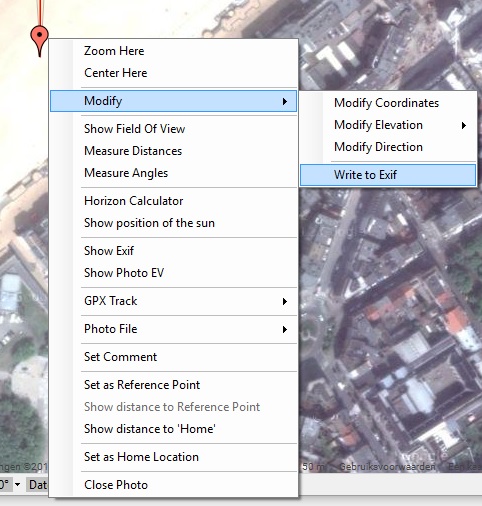
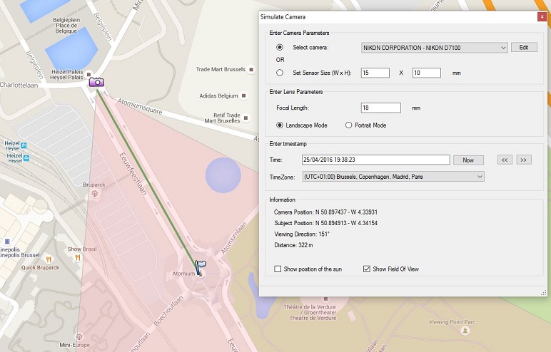
Photo GPS Extract can run a camera simulation: you can select the location of the camera and subject on the map. The program will then tell you the displayed field of view and optionally the position of the sun. It can help you to prepare for a certain photoshoot.