
I am excited to announce the return of the popular Photo GPS Extractor software. This tool has undergone a significant upgrade, overcoming previous challenges with Google Maps integration. I have transitioned to a new, robust mapping system, combining the strengths of GMAP.NET and Open Street Maps, to provide a more seamless and efficient user experience.
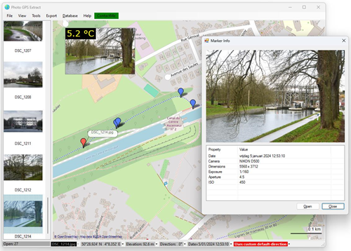
Photo GPS Extractor is a program designed for both amateur and professional photographers, geographers, and digital enthusiasts. It offers a capability to instantly visualize the GPS coordinates of your photographs on an integrated map. This user-friendly tool supports loading individual photos or entire folders, seamlessly plotting each image location with a marker on the map.
The software is not designed to serve as a digital photo management system; the market is already saturated with such tools. Instead, this tool specializes in extracting coordinates from photographs and carrying out actions based on their locations. The latest version even has the capability to maintain a database of all your GPS (GPX) track logs. This feature will enable you to swiftly locate all tracks recorded within a specific region. Additional filtering options are available to refine searches by parameters such as speed, distance, date, and more.
Note: Please be aware that this software is currently under development. Because of the frequent changes, this demo version is currently provided without an installer.
The software has some advanced features and functionalities:
Our latest version of Photo GPS Extractor emphasizes user accessibility and efficiency. The integration of GMAP.NET with Open Street Maps not only resolves previous limitations but also introduces a more intuitive and responsive mapping experience.
The Photo GPS Extractor software is pleased to introduce a suite of additional, innovative functions designed to enhance your photographic and geotagging experience. These features are tailored to meet the diverse needs of photographers, geographers, and digital enthusiasts.
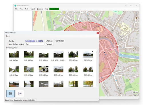
The Integrated Photo Database allows you to maintain an index of photo folders on your computer, storing GPS coordinates for each image. This powerful feature enables rapid photo retrieval. Key highlights include:
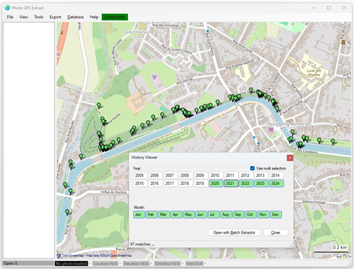
A new addition is the History Timeline Viewer, which uses the photo database to display the locations of photos taken in specific years and months.
Visualizes Time-Based Data: Shows locations on the map within the visible area that match your selected time frame, each represented by a dot, offering a unique historical perspective of your photo collection.
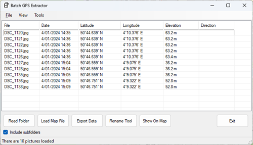
The Batch Extractor is a tool that effortlessly processes entire folders, extracting GPS coordinates from all files, including subfolders. This feature supports Multiple exporting Formats: Allows exporting of the GPS data to various formats such as GPS, Google Earth KML/KMZ, CSV, HTML ...
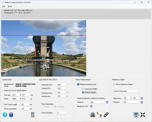
The Physical Measuring Tool is a feature that allows you to make actual measurements on photos. Utilizing the recorded focal length (zoom) of the camera and the distance to a remote object, it calculates the dimensions of that object. This tool is perfect for Real-World Measurements: Calculating the height of trees, buildings, or any other objects in your photos.
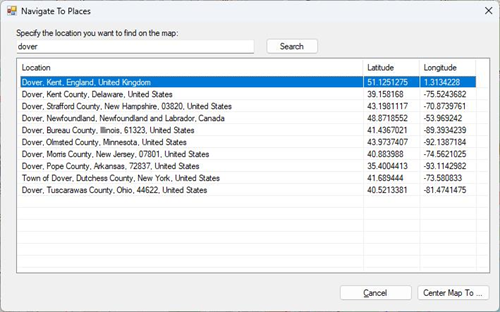
The Photo GPS Locator is a unique tool that helps you with landscape photos. It allows you to mark Points of Interest: Identify specific coordinates on a p hoto, such as a panoramic mountain shot, and mark places of interest (like nearby cities) on the map.
The GPX database feature allows users to efficiently manage and search through GPX tracks by setting up a dedicated database. Users can create or update the database index by specifying the directory containing their GPX files. This setup enables the seamless synchronization of the track database with the main map screen, displaying tracks recorded within the visible map area and updating in real-time as the map is navigated.
This feature is designed to make the management and retrieval of GPX tracks more intuitive and efficient, catering to the needs of outdoor enthusiasts and professionals alike who require detailed and precise track navigation and analysis.
Key functionalities include:
Read more about the GPX database ...
Disclaimer: the software is free but user agrees to use the Software at their own risk. I am not responsible for any direct or indirect damage, or any other losses, costs, or expenses of any kind which may arise, directly or indirectly, through the access to, use of, or reliance on the Software, or any content on the Software.